
TraMIR: Traditional Musical Instruments Room
ΕΥΔΕ-ΕΤΑΚ
(2021-2023)
Greek geographical area exhibits a quite robust music heritage blending musics, instruments and cultures of different areas, historical eras and cultural environments. While these musics are maintained and revived to some extent in the contemporary era, a significant part of the Greek audiences –especially the young ones- either is unaware of this important heritage either it does not have access to its knowledge through contemporary and efficient methods.
The proposed project will create a “Music Room” for discovering, getting in touch, learning and interacting with the Greek folk music instruments which will be realized in a 3D version. The visitor of this room will be able to hold the music instruments while wearing virtual reality(VR) glasses and discover the geographical areas these instruments represent through a digital map. She will receive information on the music instruments, their performance combinations (two or more instruments playing together) and their musics. Due to quizzes she will have an enhanced interactive and gaming experience. While Greek traditional musics are an integral part of Greek traditional dances, we propose an experimental application of motion detection in order to give the visitor the chance to try the steps of some traditional dances connected to the instruments showcased. Motion detection will be realized through contemporary deep learning techniques and neural networks. Eventually, the platform will give the visitor the chance to get introduced to traditional musics through a live, fresh and evolving experience, living behind the usual static and old fashioned experiences connected with Greek folk music. Folk and History Museum of Xanthi-Progressive Association of Xanthi will be the host of the platform to perform its realization. As a cultural organization with a strong background in managing and promoting traditional culture, community and education, it boosts the project’s intention to approach Greek traditional musics with a modern perspective. The suggested platform will stand as an important tool for promoting cultural heritage, cultural education for a wide age range of audiences, more efficient teaching of the music course at schools and enhancement of the tourist experience.
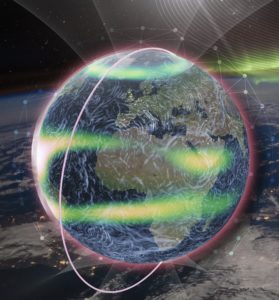
Daedalus: a low-flying Spacecraft for the Exploration of the Lower Thermosphere - Ionosphere
ESA
(2019 – 2022)
The Daedalus mission has been proposed to the European Space Agency (ESA) in response to the call for ideas for the Earth Observation programme’s 10th Earth Explorer. It was selected in 2018 as one of three candidates for a Phase-0 feasibility study. Also selected were Stereoid and G-Class, both carrying synthetic aperture radars in novel ways aiming to provide views of processes at the Earth’s surface. The goal of the Daedalus mission is to quantify the key electrodynamic processes that determine the structure and composition of the upper atmosphere, the gateway between the Earth’s atmosphere and space. An innovative preliminary mission design allows Daedalus to access electrodynamics processes down to altitudes of 150 km and below. Daedalus will perform in-situ measurements of plasma density and temperature, ion drift, neutral density and wind, ion and neutral composition, electric and magnetic fields and precipitating particles. These measurements will unambiguously quantify the amount of energy deposited in the upper atmosphere during active and quiet geomagnetic times via Joule heating and energetic particle precipitation, estimates of which currently vary by orders of magnitude between models. An innovation of the Daedalus preliminary mission concept is that it includes the release of sub-satellites at low altitudes: combined with the main spacecraft, these sub-satellites will provide multi-point measurements throughout the Lower Thermosphere-Ionosphere. The synergy with ground-based volumetric imaging of the ionosphere-thermosphere by E3D was an important argument of the Daedalus proposal. We specifically discuss how Daedalus and E3D measurements would complement each other.
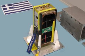
DUTHSat: A Greek QB50 nano-satellite for Upper Atmosphere Studies
EU, FP7-SPACE
(2011-2017)
The Laboratory of Electromagnetism and Space Research of the Democritus University of Thrace (DUTH/SRL) has been selected to join the QB50 European initiative for the launch of 50 nano-satellites in the upper atmosphere by January 2016. The aim is to investigate with multi-point measurements the transition region between the atmosphere and space. The 50 nano-satellites follow the CubeSat standard, where a CubeSat is a modular satellite of standardized dimensions, assembled using primarily commercial, off-the shelf components. This provides an excellent opportunity for the launch of a Greek miniaturized satellite that is entirely built by University students and engineers. Through the QB50 program a launch opportunity and part of the science payload are provided whereas the development of each CubeSat and the ground station for communications and operations are built by the host institution. In this paper we present the objectives of the QB50 mission and the status of development of the Greek QB50 CubeSat.
As a payload for QB50, the satellite carries a multineedle Langmuir probe (mNLP) sampling the electron density of the space around it, Thermistors and a Magnetometer.The secondary payload is DUTH’s ASCIs Board and ULPDAQ chip.The satellite was launched with the bulk of the QB50 constellation to the ISS in 2017, from where the satellite was deployed on 25 May 2017.
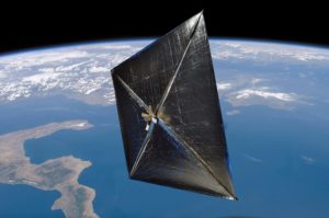
DeOrbit Sail: A Spacecraft Mission to deploy sail in Space
EU, FP7-SPACE
(2011 – 2017)
The DeOrbitSail project is a low cost end-to-end space mission, which will demonstrate satellite deorbiting through the deployment of an ultra light 5 m x5 m sail, which will fit in a 3U CubeSat nanosatellite platform. The DeOrbitSail is an EU-funded (European Union, FP7 project) space mission to demonstrate the ability to deorbit space junk using a low cost, ultra light solar sail as a drag sail, bringing debris closer to Earth so they can eventually burn up through friction in Earth’s atmosphere.
The Deorbitsail project is a collaboration to build a 3U CubeSat sized satellite with a deployable sail that will demonstrate rapid deorbiting. The deorbiting capability of the Deorbitsail satellite is due to solar radiation pressure and to increased aerodynamic drag from the large surface area of the deployed sail in LEO (Low Earth Orbit).
DeorbitSail is a demonstrator mission: its purpose is to raise the technology readiness level of a deployable sail system. The Deorbitsail team hopes that an increase in TRL will make this low-mass, low-energy deployable sail an attractive deorbiting subsystem for future spacecraft, and therefore mitigate the problem of space debris.
It is estimated that the Deorbitsail system will be suitable for deorbiting satellites of 20 -500 kg from orbits below 1000 km within the guideline time of 25 years.
MESUDEMO: Methodology for establishing a database on transport supply, demand and modelling in Europe
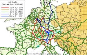
EU, FP4 – TRANSPORT
(1997 – 2000)
To develop a methodology for the establishing of general European databases on passenger, goods and traffic flows. The methodology will address the establishing of the framework of the database as well as supply a procedure for estimation of those variables which are urgently missing in the database. The database will cover the EEA + Switzerland, and take into account a progressive inclusion of the CEEC/CIS countries.
A zoning system for the structuring of actual transport flows by way of spatial aggregation into major transport corridors and networks will include interregional flows within EEA + Switzerland, flows in and out of the EEA, flows connected to the CEEC/CIS, as well as important external sea links. It must also be possible to distinguish transit flows from flows between neighbouring countries.
The project will furthermore be geared to the needs for more permanent solutions to transport infrastructure information, given the insight already gained in other tasks whether already finished or still running.
The project also aims at establishing sets of methods for creating a European database on Transport Infrastructure. Also here the database will cover EEA + Switzerland, and take into account a progressive inclusion of the CEEC/CIS countries. The combination of transport flows with network data is essential to the understanding of transport. Through the project this combination will be emphasised. Thus the perspective on infrastructure is the European context, although the research will not be restricted to information about TEN, while much of the existing, relevant data aims at national needs. How to overcome this problem will be a very important result from the project.
CONCERTO: Concertation Action for European Information Systems

EU, FP4 – TRANSPORT
(1997-1999)
The European integration process and the economic growth have stimulated freight and passenger traffic among the Member States with increasing congestion and environmental risks. An adequate information tool at the European level was deemed most necessary by policy makers to look for sustainable solutions to transport needs. Many research projects within the Strategic sector of the Transport Research Programme have contributed to the development of the European Transport policy Information System (ETIS), focusing on national transport databanks, identification of data gaps, data collection and database methodologies, definition of basic concepts and standards for the ETIS, and development of a pilot prototype. The variety of the issues and the need for streamlined planning and co-ordination were the reasons for the launch of the CONCERTO project. The CONCERTO project aimed to be a permanent forum supporting the implementation of the European Transport policy Information System (ETIS) and assisting the Concerted Action Committee on Information System (CAC-IS) in exchanging research results and making the ETIS useful for the European Commission, the Member States and the different user groups. Specific objectives of the project were:
- To promote the development of the ETIS by involving the on-going research projects in the Information Systems domain, the Member States and the Commission;
- To support and facilitate the linkage of the research activities on ETIS with the operational needs at a European level;
- To identify development guidelines for the ETIS able to anticipate policy making and technology evolutions. In a second phase of the project the following objectives were added:
- To develop a pilot study to demonstrate the need and to test the feasibility of the ETIS in the Transalpine area;
- To assess, with a forecasting model, transport and socio-economic effects of the closures provoked by unforeseen accidents of two main Alpine tunnels.
MYSTIC: Towards Origin-Destination Matrices for Europe

EU, FP4 – TRANSPORT
(1998 – 1999)
In order to develop effective transport policies, reliable data collection systems and databases, statistical analysis models and forecasting tools are needed to anticipate future developments. This is essential for assessing needs for transport infrastructure and evaluating the likely benefits of policy actions. In addition, transport operators and infrastructure providers need origin-destination information, so that they can plan their investment in facilities, operations and marketing with confidence. Until recently, customs records have provided a data source on freight movements for this purpose. However, this source has been lost with the disappearance of customs duty between Member States. MYSTIC aimed to develop and test methodologies for building origin-destination matrices for passenger and freight transport at a pan-European level from currently available data, and to chart a process for updating matrices in the future.